Where it All Began

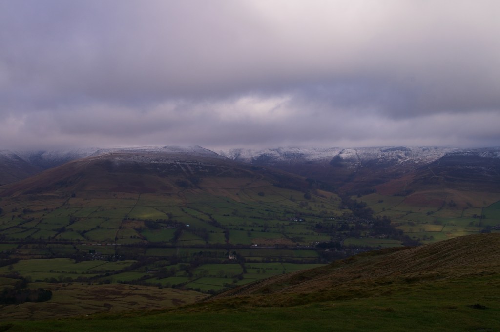
Like most good ideas, this one started in a pub. This particular pub was ‘The Old Nags Head’ in Edale within the Peak District. Myself and my good friend Barry had spent a very wet and miserable morning walking the hills around Edale, on a Saturday in Early spring 2008.

As we sat drinking our pints, Barry told me about a colleague who had recently attempted to walk to Everest Base Camp (EBC), however he came down with altitude sickness and was unable to make it to the end point. My response to this was “Soft” and that we could do it.

We were both 24 at the time; Barry had always been a fitness enthusiast and I was doing morning circuit training with an ex-army PT instructor twice a week. Everest Base Camp was as good as done! So we put our money where our mouths were and started to plan.

After some research, we determined the best time to go would be autumn or spring, so we chose Autumn 2009, to give us more time to train and save up for it. We found a travel company that specialised in these types of trips and booked through them.

There were two options we could take: the standard EBC route or the more challenging route to EBC via the Gokyo Lakes. Naturally, to prove how hard we are, we picked the latter. We managed to rope another friend Pete into the endeavor and after a prolonged nagging campaign, I also convinced my brother, also called Pete, to join us.

Over the year we continued training and did some walks in Snowdonia to prepare us for the Himalayas. However as the date approached Pete dropped out and Barry wanted a career change and was due to start teacher training in September 2009. That left me and my brother.

Barry instead took the normal EBC route in spring 2009. He came back a little broken after suffering a stomach bug throughout most of the trek; he did make EBC though. This didn’t sit well, as it dawned on me, that this could be harder than I anticipated. However hearing from his experience and what he had learnt, bolstered my excitement for it and allowed me to refine my gear choice.

At the time I was in a minimum wage job and Pete was still at university, resulting in us equipping ourselves on a budget. The two things we splashed out on, were a warm sleeping bag and footwear. I got some Brasher walking boots, that lasted me years and had been by far the best pair of boots I’ve ever owned. It was a sad, sad day when they gave up the ghost while climbing Barrow in the Lake district.

Red = Route to EBC : Green = Return Route

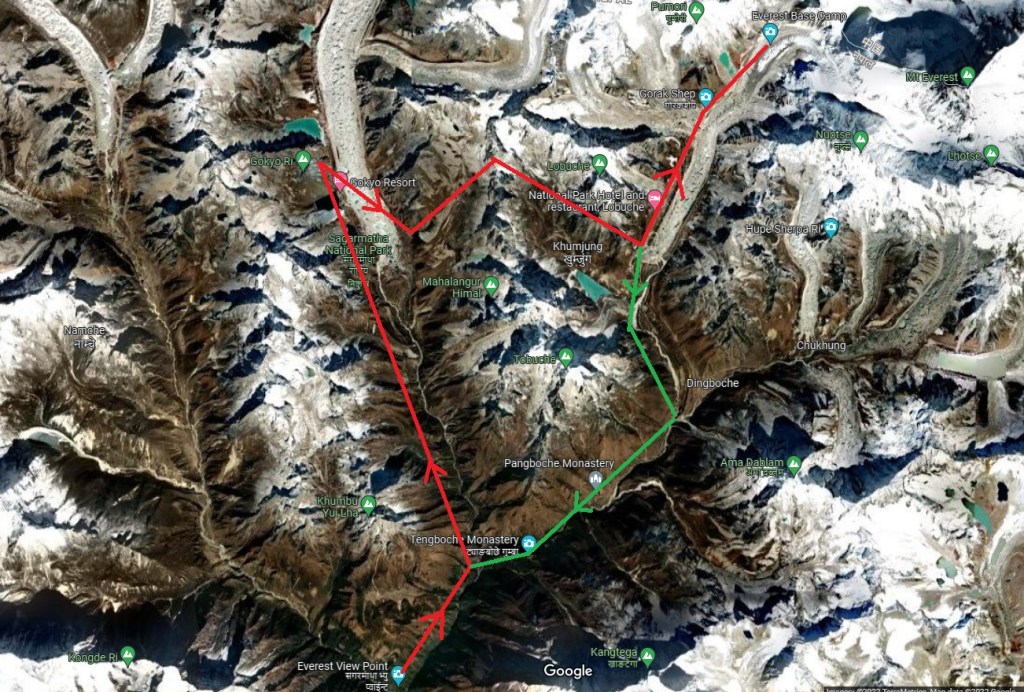
The route we took starts at Lukla, the location of the most dangerous airport in the world. From here to the Sherpa capitol, ‘Namche Bazaar’; where we took a rest day to aclimatise to the altitude before moving on to the the Gokyo Lakes, to climb the mountain ‘Gokyo Ri’.

There are two glaciers in the region that we followed; ‘Ngozumba Glacier’ where you will find the Gokyo Lakes and the more famous, ‘Khumbu Glacier’ where EBC sits. The two glaciers are separated by the huge peaks, one of which is the towering ‘Cholatse’ at 6,440m. To get between them, you cross the ‘Cho La Pass’.

Once we conquered Cho La Pass we made our way to ‘Gorak Shep’. the last village before EBC. We would then go to EBC before climbing ‘Kala Patthar’; we then descended to ‘Tengboche’ before returning to Lukla.

In a nutshell, that is the background to my adventure in the Himalayas, between the 16th October 2009 to 6th November 2009. The start of my love affair with travelling and long distance hikes.

Retrospective Blogs

I had an idea of writing a blog about my Everest Base Camp and Kilimanjaro adventures I did some years ago.

For both of these trips, I kept a travel journal to document these amazing experiences and I plan to use it in this series of blogs.

In the next few days, I will be doing some alterations to my site and start releasing a post a little more often, in the lull between my current adventures.

Keep an eye out for them and I hope you will enjoy reading about my jaunt in the Himalayas and Tanzania.

Bath

Today has been a good day on the way, despite the claggy mud. The weather held out and didn’t rain until 1700ish, giving me almost two hours spare.

I fuelled up with an omelette for breakfast before hitting the trail at 0830hrs. The route went to Tormarton and over the M4 before cutting across farmland.

More Storm Damage

It remained flat until 10 miles in, where the route dipped down into a valley and back up. There was a message box halfway up a steep section. I paused to have a read and add my own; it gave me an excuse to have a rest.

Once out of the valley I arrived at the site of the Battle of Lansdown. Where Sir William Waller for the parliamentary fought against Sir Ralph Hopton for the Royalists. They were childhood friends but ended on opposite sides of the war.

As I was making my way around the empty field, I met a walking group who were being led by two volunteers for the Cotswold Way Association. They spied my backpack and stopped for a chat. Apparently I can upload a picture of me at the abbey on their website’s “hall of fame” for completing the whole way.

It remained level from here until I skirted around Bath racecourse where I got my first glimpse of the end point. Still two hours of walk ahead of me; I pressed on.

I still had one more hill to tackle before the finish line; Primrose Hill. This sits between Weston and Bath. After cresting this it was a leisurely descent to the finish line.

Outside the abbey it was very crowded so I couldn’t get to the end point plaque; I returned later once the rain had chased everyone away.

Inside the abbey, it reminded me of Leon cathedral, with the high ceilings and stained glass windows. After a walk around Bath, I got some food and retired to my hotel to rest my weary legs.

Old Sodbury

The word of the day is ‘mud’. Yesterday’s rain has caused the paths to form a claggy muddy mess. Each step caused my foot to slide, then it would stick to my boots! Several times I almost did the stranded turtle pose!

As I wouldn’t be camping for the rest of the trip and to lighten the load enabling me to pick up the pace, I sent my tent and sleeping bag back home. Only snag was the post office didn’t open until 0900hrs. By the time I got it all sorted it had gone 0930hrs.

The late start and the mud underfoot slowed me down, however the uphills where now easier! Straight out of Dursley the ascent was devilish. Already offloading the tent had paid off.

The path then went immediately downhill into North Nibly with its huge monument looking over the village. I just knew I would be climbing up to it, and I was correct!

After the steep incline I got to the top where I was presented with panoramic views and the river Severn in the distance; I could even see the white towers of the ‘Severn Bridge’!

If you Zoom in you can see the Severn Bridge

I then descended into Wotton under Edge just as I had the first and only rain shower of the day. Other than that it remained sunny. A stark difference from the day before; I put my umbrella to good use.

Coming out of Wotton was my third steep incline; that’s three in 6 miles! I got chatting to a fellow walker following the route northwards. Thankfully he said it’s mostly downhill into Bath.

Leaving Wotton

As it is Saturday, there were plenty of people out enjoying the good weather. Seeing me with my big backpack peaked their interest and I stopped to chat with them. It was great to have a friendly chat to spur me on.

From here on it undulated but no more big climbs. As I descended into Wortley the path followed a narrow muddy ravine that was blocked by a fallen tree; another casualty from the storms.

After a bit of a muddy scramble I circumnavigated it before reaching Wortley and Alderley where I stopped to eat my sandwiches.

I continued on into Hawksbury Upton where there was a field of lambs chasing each other. I paused to take in the moment before plodding on. It wasn’t long before I entered Little Sudbury where two lovely elderly ladies walking their dogs spotted my backpack.

I’m glad I stopped to chat with them as they gave me an alternative route to my BnB that avoided walking along a busy ‘A’ road; a bit of Cotswold magic?!

Despite starting very late I arrived just after 1630hrs. It had been a good day on the way, only one more to go. Tomorrow Bath.

Dursley

Today was easier but only just despite the rain. I set off about 0730hrs to get 30mins walk in before the rain was predicted to set in. Most of the trek today was in woodland thus little picture opportunities. However I have crossed over the halfway mark!

The route immediately went down hill to my heart’s discontent. One thing I have learnt quickly, is on the Cotswold Way every decline is followed by steep inclines.

I passed trees with yellow arrows painted on them; a sign of the Camino! I took this as a good omen.

Once I reached the bottom of the woodland it was level for 3 miles until the first short, but fierce incline of the day to summit Cooper’s Hill. As I reached it the rain arrived. I was lucky to get an hour walk in the dry.

From here I had one other climb over Buckholt nature reserve before arriving into Painswick. I called into the local shop to buy a sandwich and snacks for the day.

I had lost sight of the way markers and got a little lost in the village before I grabbed my map and found the route again.

Painswick Church

From Painswick, the path went down hill fast which only means an uphill is on its way, and it was there in front of me, taunting me. Once I reached the crest it was a gentle decline through woodland before reaching a country road.

I followed the road down about 1/4 of a mile before the path turned off and up a hill. But as I reached this, the forestry committee had blocked it off. Apparently due to the storms we had two weeks earlier had made this part unsafe.

The diversion was back up the road which eventually joined the Cotswold Way on the other side of the blocked off section. It was also a longer!

I eventually descended into Ryeford passing a vineyard (another reminder of the Camino) and crossing a canal, before I hit two very steep hills to reach Coaley Peak. Here I got my first look at Dursley in the distance.

Sorry Looking Vineyard

I followed the ridge line of the hill before the descent into Dursley. At 1700hrs the sun had decided to show itself giving a pleasant stroll to the end of the day.

Today was harder on my feet as the terrain was hard under foot or very slippy cobble like stones that were wet and muddy. Hopefully tomorrow will be drier!

Birdlip

Well today didn’t stick to the script. It felt like it has been up hill for 22 miles; of course it wasn’t, but it certainly felt like it. I certainly found it tough today.

I left the campsite just before 0900 and covered the 2 miles to Winchcombe in no time, passing the ruins of Hailes abbey. I called into a newsagent for a meal deal as there are no villages between Winchcombe and Birdlip.

Abbey Ruins

I made my way back on the Cotswold Way, starting the incline up to Belas Knap Long Barrow. I got chatting to a couple who had done the Camino!

From the barrow the route cut across farmland before descending through woodland to Postlip. the small hamlet dominated by Postlip Hall.

Postlip Hall

From here it was an ascent to Cleeve Hill with a head wind. I stopped just before the summit for lunch before continuing. The way follows the edge of the hill range, winding around crags and sharp drops. The path skirts south of Cheltenham, giving lofty views of the city and the racecourse.

Cheltenham racecourse

Soon I hit a descent before again climbing another steep hill, this one too snaking around the edge, eventually overlooking Gloucester. At this point the light was fading and I still had some distance to cover.

Gloucester

After making my way down I reached Ullenwood. It was 1720hrs at this point and the route took a right through the village. I was really flagging and I sat on a grit box at the side of the road to assess my options.

If I followed the Cotswold Way it ascended another hill or two, continued to snake around the edges before reaching Birdlip; another 4-5 miles at least.

However Google maps showed I was 1.8 miles away from my destination. But meant I would have to follow an ‘A’ road; unless I cut across a woodland park, involving short but steep hill!

It would then join a country road into Birdlip. My options were follow the route, take the short cut or get a taxi; the taxi was very tempting.

I took the short cut. I arrived at the BnB at 1820hrs. 22 miles I covered today. Not bad considering I had little sleep from the wind and owls hooting all last night.

The many hills today slowed me down. Tomorrow it is forecasted for rain and if I’ve calculated it correctly, it’s another 22 miler! Poncho time.

Hailes

I set off at 0830hrs into the crisp sunshine; not a cloud in sight. It was straight up hill from the get go to reach the summit of Dover’s Hill. I was presented with views across the Cotswolds.

From here it remained relatively flat, crossing farmland and through small copses before reaching Broadway Tower. From this vantage point you can see the village nestling below.

The descent was quite quick into the village where I stopped at a picnic bench for a short brake. It was 1100hrs and I had done 6 miles; too early for lunch.

Leaving Broadway, the trail went up a long drawn out incline for 3 miles which was quite exhausting; the head wind didn’t help. As soon as it levelled out, it steeply descended into Stanton where I stopped at the Mount Inn for some food and a cold class of orange and lemonade.

From here the route passes through fields scattered by oak trees. The quintessential Cotswold landscape. I even spied a deer grazing, but it was too far for my phone to pick out.

I passed through Stanway with its stately home and grand gatehouse in a blink of an eye. Crossing the main road into Stanway Wood, marking the start of the last hill for the day. This was a steep ascent that was gruelling. My knee started give me a bit of bother which slowed my pace.

By 1600hrs I reached my campsite at Hailes, pitched my tent in the wind and settled in. Unfortunately at 1900hrs it began to rain. Not what my weather app predicted!

Still it was good to get walking again. At times my mind drifted to memories of my Camino. I felt back in my element.

Chipping Campden

Catching the Train

I’ve arrived in Chipping Campden ready to start the Cotswold Way in the morning. The weather had been clear skies and sunshine until I hopped off the bus.

Getting here was easier than I thought. Three trains that were all on time to reach Stratford upon Avon, then a bus to Chipping Campden. The only hitch was the bus stop was closed due to a closure, but there was no signage to indicate this. If it wasn’t for a local resident telling the now long queue about this, I would probably have had to spend the first night in Stratford!

I booked into my BnB which sits right on the route. I dumped my bag and had a walk around up to the start point of the trek. I was hoping for a plaque or sign to get a selfie with, but there isn’t. The route according to the map starts at the church.

Just round the corner from here is a little pub called the ‘Eight Bells’. I called in and reserved a table for food and settled in with a drink as it started to rain outside.

The forecast is winds tomorrow; that should be fun for pitching my tent up. Just hope it’s a tail wind to help me on my first long day of walking since the Camino.

Cotswold Way

Daventry Country Park

It’s been almost 5 months since I returned from the Camino de Santiago and I’m itching to get walking on another adventure; my strolls around the local country park and area have not been sating my thirst for the outdoors and my planned Camino Portugues in August is too far away for me to wait.

Once again I’m back on YouTube watching trekking videos. Two have caught my eye; Hadrian’s Wall and the Cotswold Way. Hadrians Wall was a consideration for my Prostate Cancer UK charity walk back in 2020, but the Cotswold Way will be easier for me to get to and from.

According to the Cicerone guide, the 102 mile trek is usually done over 13 stages. However, I only have one week leave from work; so I’m going to attempt to cover that distance in 5 days. I’ll be starting in Chipping Campden on the 9th March and arriving in Bath on the 13th.

It will be a mixture of camping and BnB due to the lack of campsites at the stage ends I plan to stop at and Judging by the recent weather, it maybe on the chilly and wet side! The equipment I took on the WHW will likely cut it for the March climate, however, I feel I would benefit from getting a sleeping mat suited for colder weather.

Through my obsession of gear review videos I’ve learnt that getting a warm sleeping bag is only half the job. The insulation doesn’t work if compressed; you can have the best, all singing and dancing sleeping bag in the world, but it will not stop the cold seeping in from the ground where it is squished by your body.

Not to get too technical, but the efficiency of a sleeping mat is measured by the “R” value. The higher it is, the warmer it is. Off the back of my WHW adventure, I looked into sleeping mats, as the inflatable one I took has a low rating that resulted in a couple of cold nights.

A cheap option is to buy a foam mat with a good R value and use my current inflatable one on top of that. This can save a lot of money, as you’re looking at over £100 for a decent inflatable one.

I picked up a folding mat in a sale a year ago, but it’s still very bulky; I keep eyeing it up and I can’t bring myself to lug it around on a thru hike. I hit the internet in search of a 3+ season inflatable mats.

I’ve settled on the Exped Synmat 7. It’s a bit on the heavier side at 855g, but the lighter ones are weightier on the wallet. I had a few gift cards from Christmas that I put to good use in this purchase.

Exped Synmat 7

The route starts in Chipping Campden, an important market town for the wool trade in the 17th century. I’ll be making my way there by bus and stopping a night before setting off in the morning. My journey will pass many battle sites from the English civil war, ancient Roman settlements, quaint villages before arriving in the historic spa town of Bath, where the route terminates at the abbey.

I’ll be swapping the yellow arrows that guided me across Spain, for acorns that mark the route through the Cotswolds. Fingers crossed the weather will be kind to me!

Once a Pilgrim, Forever a Pilgrim

It has been six weeks since I left Santiago de Compostela to return home and to the real world. The transition from the Camino life to “normality” has been a journey in itself. I have the constant urge to walk, both mentally and physically. My legs have been seizing up if I sit for too long. The 30 min drive to work has me exiting the car like an 80 year old; I recently drove up north to visit family and after an hour, my legs were in pain!

I’m still decompressing from the whole trip. It is such an intense journey, you can’t process the experiences while you’re walking it. You just have to live in the moment and accept everything as it comes. Now that I am home, I am getting the time to mull over the pilgrimage and let it sink in. It is said the Camino doesn’t end at Santiago but continues throughout your life; I feel this is true. The lessons I’ve learnt along the way will stick with me forever and the memories I’ve made, make me smile.

As I go about my day, I find that something will spark a memory of a particular moment during my Camino; this gives me time to pause and reminisce about my magical journey. The friends I made will always be in my thoughts and as is the way of the Camino, I’m sure our paths will cross again in the future. In fact, we have had a few zoom meetings since returning to catch up! The Whatsapp group I had set up back at the beginning of the trip, is buzzing practically on a daily basis.

Before going into this adventure, I was a little concerned that at the end I would get the ‘Camino Blues’, but so far I haven’t experienced them. I don’t feel sad that it is over, as like I said, the Camino doesn’t end in Santiago. Don’t get me wrong, I miss my Camino Family, the pilgrim community, the structure of the daily life, the solace of the walk and the ‘Tortilla y Patata’! Every time I think back on my Camino, it is fondly and there are no “blues”.

This now begs the question “What’s next?”

My sights have settled on the ‘Camino Portugues’; another pilgrimage to Santiago but starting in Porto, Portugal. This is a shorter route compared to the Camino Frances, that can be done in 10 days; according to the guide book by Harms, Dintaman and Landis.

There are two routes from Porto you can take; the Coastal or the traditional Central route. I’ve chosen the Central route as there is a mountain to climb, Alto de Portela Grande; I like a good hill to summit!

The Camino Portugues is the second most popular route next to the Camino Frances, and likely as people become more confident venturing abroad, I expect it to be quite busy next year; but this doesn’t deter me, just means there are more pilgrims to meet! It is the people you meet along the way that make the journey so special.

I’ve booked leave in August thus I will be sure to pack the sunscreen! I aim to blog this trip like the Camino Frances, so stay tuned! Till the next time, Buen Camino!